Wednesday, February 22, 2012

Ecological Assessment And Its Aftermath After Tropical Typhoon Washi (“Sendong”) Triggered Mindanao Island From 15 to 17 December 2011

Latest Update On Ecological Assessment of Cagayan de Oro City and Its Vicinities After Tropical Typhoon Washi (“Sendong”) Triggered Mindanao Island From 15 to 17 December 2011.

Flood of the century
1916 flooding was known to Cagayanon's memory as the biggest and the recent one could equal it. The confluence of event: Typhoon Sendong (Washi) was formed in east of Mindanao Philippine Sea area near the equator-center of earth's rotation and gestating several days over warming ocean. The storm sucked huge amount of water not precisely measured, accurately tracked and well informed to the public. NASA satellite images and Manila Observatory, Ateneo de Manila 3-hour interval images of Sendong showed 40 mililiters of rain were concentrated in 50 kilometer radius with cyclonic character of great deluge as witnessed by local residents and officials.

It struck midnight during Christmas holiday where everyone in revelry, partying and shopping. Good for those outside the flooded areas but woes to those caught by surprise and sleeping. All barangay and purok along Cagayan river banks from Bukidnon river barangays down to Macabalan were shaken by strong waves of flashflood "tsunami like" up to 30 feet high and its fury took a toll of more than a thousand souls. 

Related flashflood and widespread flooding of Iponan river devastated Iponan, Barra-Opol in Misamis Oriental. Equally devastating Mandulog river in Iligan City and suburbs claimed also nearly equal number of souls and missing. 

Humanitarian Action

Huge search and rescue efforts were no match to the mega-disaster under black-out and lack of coordination and poor communication. The rest of Cagayanon were incapacitated by heavy rains, darkness, lack of transport and surging water flooding nearly a third of the urban center.

Every Cagayanon rallied for action to document, publish and provided emergency relief and appeal for assistance on behalf of affected communities. Local and international civic and emergency relief organizations responded swiftly with foreign governments and local agencies. 

Food, water and sanitation were the immediate concerns and dwellings for devastated families. Local barangay and civic organizations coordinated in providing these urgent needs and temporary relief. Cagayan de Oro faced-off with squabbles between local politicians, aid agencies and church organization.

Relief concerns on water supply dragged for 4 weeks. Housing, resettlement and health concerns are remaining challenge with outbreak of leptospirosis and recently dengue fever. Politics and "playticians" exploit their opportunities to make windfall of the disaster and traditional aid assistance. Promises and commitments for resettlement, reconstruction and rehabilitation were projected this year and coming future. These remain to be realized while evacuees and affected families felt uncertainty of their future.

Rehabilitation of victims and affected communities were also a great challenge along with reconstruction of affected areas and recovery from trauma (10 victims already commited suicide) and loss of livelihood and businesses. Most important bridge connecting Cagayan de Oro City to Baungon, Bukidnon need to be repaired and reconnected as soon as possible in the next 6 months or danger of hunger, diseases and instability will stalked local communities up-river and upstream in municipality of Baungon, Bukidnon.

Ecological Assessment of Cagayan River

Briefly scanning the center of disaster area along Cagayan river from Taguanao down to Macabalan, physical and ecological evidence  of massive destruction were observed and eyewitness testimonies and information gathered.

Cala-cala residents of barangay Macasandig were disgusted with Gaisano and Co. quarrying, crusher and batching plants aggravated flooding in their areas. A dozen of large-scale quarrying were faulted to had aggravated the disaster by distorting natural flow of the river and its banks. Local government's cheap housing in the area is the main culprit of the huge casualties by locating it within the rivers old pathway.

Disaster risk reduction (DRR) were initiated in Macasandig and Balulang by NGO's but were not applied effectively during the disaster event. City government had just local passed DRR ordinance last December 2011 and had not set up mechanism. National and health agencies had just started their DRR training, planning and DRR team organization.

Gleaning on infrastructures along the river, most prominent the Carmen bridge structure which maybe more than 50 years is a good reference point. Measuring the city hall extension building, the cathedral church appurtenants and river bank park enclosed by dikes now; all of these structures encroached about 50 meters into the river. 

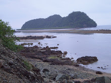
Opposite the river bank, Commission on Audit building and vicinity down river and up river may have encroached about the same width into the river. Recent infrastructure developments such as; new bridges, rotunda, river reclamations, industrial and commercial development encroached into the river's domain. Most blatant is this recent reclamation in the mouth of the river with an estimated area of about 2 hectare for industrial purpose related to quarrying or mining? Just imagine how much human development had encroached inside Cagayan river ? 

Information of the  mega-flood are evident among Cagayan river' tributaries . Cagayan-Batang, Tumalaong and Bubonawan rivers are interesting to investigate and strategic to local DRR plans.  These should also look on the transformation of upper Cagayan river landscape since January 2009 flooding and 50 years ago. This is the only way to look forward for a worthwhile 1 century rehabilitation, reconstruction and stabilization plans area-wide. We did not observed significant landslides inside thickly forested Mt. Kitanglad Range from Kalanganan, San Vicente, Baungon except for isolated information on landslides

After 5 days of reconnasaince survey, 1 farm plot we measured in Salimbalan, Baungon Bukidnon (100 died and missing). 2 hectares or 20,000 square meters and estimating 1 meter depth of landslip=20,000 cubic meter of earth or equivalent to 2,000 dump trucks of soil, rocks and sediments were flushed to Bubonawan river and downward to Cagayan river and the city. 

Calculating 40,000 hectares of watershed without forest including riparian zones (mountain slopes, cliffs & ravines, farmlands and estuarine). Assuming only 2 percent or 800 hectares eroded down the river and Macajalar Bay. There's still enormous equivalent to 800,000 dump-trucks of sediments are deposited in Cagayan river, upstream, river mouth and the bay. 

Many testimonies of century-old "balete" ficus and other giant trees along Tumalaong river were swept down to Cagayan river and Macajalar Bay. Ricelands on river deltas both in Tulmalaong and Bubonawan rivers were swallowed by the deluge with their owners and caretakers. 

Ten of thousand of landslides and landslips looked like giants scratching the hillsides and mountain slopes tearing down 20-year-old residual forest, farmlands and infrastructures. Municipality of Baungon, Bukidnon remained landlocked after 4 weeks except through 1-ton private bridge and circuitous pineapple plantation road and ranch.

Another visit in barangay Langawon, Baungon situated like an island between branching Cagayan river. It is reachable after crossing 2 make-shift hanging bridge damaged by Sendong is confirmation of my earlier hypothesis. A hundred landslides around the 1-kilometer radius including purok "Resthouse" which may become another Ginsaugon, Leyte disaster (2006). Many more communities and barangay around affected areas need immediate investigation and verification on the extent of landslides, landslips and thunder floods locally called "buhawi".

The question now how much space left to Cagayan river bed to absorbed normal floods including the likes of Sendong without endangering surviving residents and the city this year and in the future? Will another destructive mega-flood will likely to recur this year and immediate future? Accordingly to most eyewitness and survivors. Cagayan river bed is heavily silted and filled with sand and rock.  The internationally famous attraction of white-water rafting reduced its rapids from 5 from 19.

The mega flashflood had transported huge amount of earth sediments, sand, gravel and rocks and deposited from various sources. Landslides and  landslips along the hillsides, mountain slopes, farmlands and networks are are main contributors of silts, sediments and boulders in the upstream, Cagayan river and Macajalar Bay. Whereas, farm erosion and landscape run-off of contributed their part of the flooding but no match to the 8 hours deluge within 8 hours over 50-kilometer radius of Cagayan, Iponan and Iligan-Mandulog rivers. 
The "epicenter" of the deluge located around the confluence of Cagayan, Tumalaong and Bobonanwan rivers with about 100 landslides in 1-kilometer radius is not more than 15 kilometers from downtown Cagayan de Oro City. 

Recurrence, Risk and Reconstruction

Probability of 50-50 chance that both human and climatic factors are responsible into this recent disaster event. Surrounding agricultural, residential and commercial development had their own share of the flooding and siltation. This are trickle in the bucket in comparison to million cubic meters of earth flushed-down by Sendong in Cagayan-Iponan-ILigan river towards the bay.

Rehabilitation and reconstruction should involved both down-river (Cagayan de Oro-Opo-Iligan) and upriver (Baungon, Bukidnon; upper Iponan, Cagayan de Oro and Mandulog, Iligan/Lanao Norte ) rivers communities. They appear suffered the same by the onslaught of Sendong and its aftermath.

Philippines science experts on marine and aquatic hydrology along with local experts on geo-meteorological assessment should be mobilized in next 30 days. Global cooperation with IPCC, NASA, NOAA, TRMM,  JTWC (Japan) and ASEAN should be undertaken in parallel in tracking typhoon monitoring, early warning system and coordination.

These information, development and knowledge should be shared to Cagayan de Oro community, national and global agencies with prudence and precaution. 


Reported by: Butch Dagondon, Executive Director of GREEN Mindanao, with Noah Paylaga and Joseph A. Magaña.

Wednesday, October 3, 2007

Water Project

Project Title:
The Water Project
(Potable Water Project)
Misamis Oriental, Bukidnon and Lanao del Norte
Mindanao Island

Funded by:
“Kommitee Ärzte für die Dritte Welt”
Germany

Implementing Organization:
GREEN Mindanao Association, Inc.
The Philippines


The construction of water systems in several remote coastal and upland communities in Misamis Oriental, Bukidnon and Lanao del Norte provinces of Mindanao Island had funded assistance from the“Kommitee
Ärzte für die Dritte Welt” of Germany. It was implemented by GREEN Mindanao. . . The present on-going project has been started in September 2004 and will be finished on December this year (2007). It is in partnership with Hope for Change, Inc. and Life for Water, Inc. and in cooperation with the local government units of Municipal Government of Lanao del Norte and selected Barangay Councils (villages).

For more details of the project, please email us. Contact person: Mr. Albert Mabaquiao, the Project Coordinator.

Friday, September 28, 2007

About GREEN Mindanao


... is an acronym for Geographic Rediscovery of Endangered Environment and Natural Resources in Mindanao. GREEN Mindanao was founded in 1991 by young professionals, students, and environmentalists from government and private agencies involved in wildlife conservation, agricultural extension, rural development communication and mountaineering.
GREEN Mindanao started as a voluntary organization undertaking forest and mountain exploration and documentation, anti-logging, experimental community organizing and livelihood assistance trial projects.

GREEN Mindanao made to realize the following:

1. To advocate sustainable development as a guiding principle to wise natural resource utilization and its conservation in Mindanao.

2. To support the establishment and conservation of natural heritage and parks for watershed purposes, games reserves, wildlife sanctuary and ancestral lands of indigenous people.

3. To promote understanding between lowland dumagat-settlers and lumad-indigenous peoples to live in peaceful co-existence and equal opportunities to access natural resources.

4. To search for and preserve geographic knowledge about Mindanao that will sustain the Socio-economic development while maintaining ecological balance and for furtherance of science.

5. To seek cooperation and assistance from legitimate governments, organizations, institutions, and individuals that share our vision-mission in the realization of various programs and projects to attain our objectives.

the VISION…

GREEN Mindanao influences the people of Northern Mindanao to use the environment responsibly. This is done through Advocacy, Assistance of Marginalized People, Promotion of Sustainable Development and Community-Based Resource Management, Rehabilitation and Protection of Critical Ecosystems, and Links with Relevant Institutions.

the MISSION

1. GREEN Mindanao implements existing projects effectively.

2. GREEN Mindanao comes up with and implements projects related to advocacy, sustainable development, assistance of marginalized people, community-based resource management, rehabilitation and protection of critical ecosystems, linkages with relevant institutions, and it generates funds for the purpose.

3. GREEN Mindanao mobilizes members and volunteers.

Youth Alliance for Environmental Protection (YAEP)

An action-oriented environmental group and/or individual committed to the conservation and preservation of the environment through advocacy and education.

Membership

GREEN Mindanao is open to all individuals from all walks of life – students and professionals from private and public institutions and allied organizations.

There are 44 persons registered as regular and associate members excluding the volunteers who are providing voluntary services related to GM objectives on part-time and seasonal basis.

Current projects being implemented by GM include:

§ Incite Dugong and Coastal Ecosystem Hotspots Conservation Project in Pujada Bay, Mati, Davao Oriental with assistance from NC-IUCN, of the Netherlands.

§ Consolidating ADSDPP, Forest Mangement Practices and Cultural Strategies Among Higaonon Communities in Kimangkil Mountains and Ancestral Domain involving barangays Mat-I, Man-ibay, Civoleg and Mangilit in Claveria and Gingoog City, Misamis Oriental, with assistance from UNDP-SGP-PTF.

§ Promoting Environmental Management and Sustainable Development in barangays Madreliño, Tuburan, and Uba of Cortes, Surigao del Sur with assistance from the “Kommitee Ärzte für die Dritte Welt” of Germany.

§ The construction of sustainable waterworks system and sanitatioin project in several remote coastal and upland communities in Misamis Oriental, Bukidnon, Surigao del Sur, and Lanao del Sur with assistance from the“Kommitee Ärzte für die Dritte Welt” of Germany.

§ Conflict resolution to secure Mamanwa tribal lands in Surigao del Sur with assistance from CORDAID of the Netherlands.

GM is currently implementing the following projects in association with other organizations:

· GM is a member of the Caraga Consortium for Environmental Protection and Sustainable Development (CaCEPSDev), established to initiate the community-based resource management of Lake Mainit in Agusan del Norte and Surigao del Norte, with assistance from the FPE.

Past projects successfully implemented by GM include:

· Consolidating Community-Based Resource Management and Development Project involving both upland and coastal management in barangays Villa Felipa, Damayuhan, San Isidro and Kauswagan in Magsaysay, Misamis Oriental, with assistance from CORDAID of the Netherlands.

· A bay-wide proactive project designed to build public awareness and prepare institutions for ongoing community-based resource management work in Lanuza Bay, with financial assistance from the Foundation for Philippine Environment (FPE), and technical assistance from the Coastal Resource Management Project (CRMP) of the Department of Environment and Natural Resources (DENR).

· A two-year community-based resource management project involving both upland and coastal management in barangays Villa Felipa, Damayuhan and San Isidro in Magsaysay, Misamis Oriental, with assistance from Bilance/ CORDAID of the Netherlands.

· An eco-tourism development project in Magsaysay, Misamis Oriental, with assistance from Voluntary Services Overseas (VSO).

· The construction of water systems in several remote coastal and upland communities in Misamis Oriental and Bukidnon, with assistance from the“Kommitee Ärzte für die Dritte Welt” of Germany.

· An agro-forestry project involving the growing of Abaca in Barangay Minalwang, Claveria, Misamis Oriental, with assistance from CanadaFunds.

· A co-financing project for community-based forest management in San Fernando, Bukidnon, with assistance from the FPE

· An advocacy project related to commercial fishing intrusions into municipal waters and the political tensions generated in Lanuza Bay, Surigao del Sur, in 2000, with assistance from the FPE.

· A preparatory research and linkaging project in Lanuza Bay, Surigao del Sur, in 1999, with assistance from the FPE.

· A communal fishing assistance project in Barangay Damayuhan, Magsaysay, Misamis Oriental, in 1999, with assistance from the Australian Development Assistance Program (ADAP).

· A community fisheries assessment project in Barangay Damayuhan, Magsaysay, Misamis Oriental, in 1998, with assistance from the FPE.

· An ancestral domain management and forest margin agriculture project in Barangay Minalwang, Claveria, Misamis Oriental, in 1997-98, with the assistance of the United Nations Development Program - Global Environment Facility - Small Grants Program (UNDP - GEF - SGP).

· A community-based forest management and ancestral domain management planning project in Barangay Minalwang, Claveria, Misamis Oriental, in 1996-1997, with assistance from the United States Agency for International Development (USAID).

· A watershed biodiversity research and conservation project in Lantapan, Bukidnon (part of the buffer zone of Mt. Kitanglad), in 1995, with assistance from USAID through the Sustainable Agriculture and Natural Resource Management - Collaborative Research Program (SANREM - CRP).

· An ancestral domain advocacy project in Mt. Kitanglad Natural Park, in 1995, with assistance from the Conservation of Priority Protected Areas Project (CPPAP) of the NGOs for Integrated Protected Areas, Inc. (NIPA) and the DENR, supported by the World Bank - Global Environment Fund (WB - GEF).

GM has received funding support from the Australian Embassy, Bilance/ CORDAID, CanadaFunds, CPPAP, FPE, the German Doctors, the German Development Service, MISEREOR, UNDP, USAID, VSO, and the WB.


GREEN Mindanao address:

Unit M-3A, Maris de Lara St., Macasandig, Cagayan de Or0 City 9000, The Philippines

Telefax. No. (6388) 857-1645

Telefax. No. (6388) 857-2561

Email:

greenmin@home.philcom.ph

green_mindanao@yahoo.com.ph

gmwaterproject@gmail.com

Wednesday, September 5, 2007

Higaonon Tribal Ritual at Cebolig

Font size
Higaonon Tribal Ritual at Cebolig, Gingoog City

The tribe “Higaonon” once first settled near in the coastal province of Misamis Oriental in Mindanao Island, part of the southern Philippines, but this modern days most tribes went to the hinterlands and mountains of the villages. The Higaonons with their tribal council as usual they conducted tribal ritual in their traditional practices bound in their cultural heritage held at Cebolig village last 20 June 2005. The ritual had assisted by NGO partner – GREEN Mindanao. Their tribe has established a strong cultural grounds.


Text and Photo by: GREEN Mindanao
(Date made: September 2007)

Tuesday, September 4, 2007

Endangered Philippine Dugong Found Dead In Davao Oriental


Endangered Philippine Dugong (Dugon Dugong)

A dugong (sea cow) found dead by community folks at the seashore of barangay (village) Cabuaya, Mati in Davao Oriental province in July 2006. In the same year before June and August months there were sighted dugongs threatened and found dead through the coastal of the province.


Text and photo by: GREEN Mindanao Association, Inc.
(Date made: September 2007)
For more and other details, just copy and paste the link below into your browser and click "Go" or hit Enter.

Friday, August 24, 2007

Board Members, Staff and Volunteers of GREEN Mindanao


GREEN Mindanao Association, Inc.

Members of the Board of Directors:
Founder and President – Gliceto O. Dagondon
Executive Vice President – Albert M. Mabaquiao
Secretary – Gilda P. Villalba
Treasurer – Dietmar Schug
Member - Ma. Easterluna S. Canoy
Staff

Officers:
Executive Director/President – Gliceto O. Dagondon
Executive Vice President – Albert M. Mabaquiao
Secretary – Gilda P. Villalba
Treasurer – Dietmar Schug

Main Office Administrative Operation
Administration and Finance Officer - Ma. Sofia R. Monares
Bookkeeper and Administrative Assistant - Ruel Sharon Sagun
Office Assistant and Documenter - Althea L. Belono

Sub-Office Administrative Operation
Administrative Assistant - Rechie Tuldanes

Field Staff
Project Coordinator - Engr. Roel Casiñas
Technical Consultant - Abraham D. Uy
Community Development Facilitator - Meiyoshi Masgon
Community Development Facilitator - Joseph Magaña
Community Development Facilitator - Elmer Lauron

Consultants
Biology - Wilfredo Belono
Indigenous Peoples (IPs)- Rey Danilo Lacson
Marine Biology - Darwin Brian Lawas
Project Proposal - Arvin Medrano
Forestry - Galicano Mortel
Research and Education - Noah Paylaga

Community-based Staff
Tribal Coordinator – Datu Carmelito Montenegro
Tribal Coordinator – Datu Ceasar Batao
Tribal Coordinator – Datu Primo Falcon
Professional Volunteers
Selected on-the-job trainees of Xavier University Center for Legal Assistance (XUCLA)
Cecelia Rhodora

(Date updated: 24 August 2007)

Wednesday, August 22, 2007

Staff of Green Mindanao and Their Interests


1st photo: Dynamic and optimistic staff of GREEN Mindanao with different local community project partners in the upland and coastal areas in Mindanao Island.
(2nd) photo: Ma. Sofia Monares is the Adminsrative and Finance Officer. She is single, friendly, outgoing, honest, and loving.

3rd photo: . . .